
News
Flood risk assessment for proposed developments

In short: A flood impact assessment shows how a proposed development affects flood behaviour on the site and its neighbours, and how the building will perform in a flood. Councils require one when a site is mapped as flood-prone, when a council flood study identifies flood risk, or when a Section 10.7 certificate flags flood controls. The assessment sets floor levels, checks flow paths and storage, and gives the council the evidence to approve the design.
Flooding is one of the most common natural hazards affecting development sites in NSW. Before a council can approve a development on flood-prone land, it needs to understand how the site floods today and how the proposed building changes that, for the site itself and for its neighbours.
The three flood categories
The NSW Floodplain Development Manual divides flood-prone land into three categories, and the category your site falls into drives what can be built and how.
- Floodway: the areas where a significant volume of water flows during a flood. Development that obstructs a floodway can raise flood levels elsewhere, so floodways are usually kept clear of buildings.
- Flood storage: the areas outside the floodway that store floodwater during a flood. Filling flood storage pushes water onto other land, so councils limit filling and building here.
- Flood fringe: the remaining flood-prone land. Development is usually possible with controls such as minimum floor levels and flood-compatible materials.
What a flood impact assessment covers
- The design flood levels for the site, usually the 1% AEP (1 in 100 year) event and the probable maximum flood.
- Minimum habitable and non-habitable floor levels, including the council's freeboard requirement.
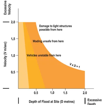
- How the building and any filling change flood flow paths, velocities and storage on the site and for adjoining properties.
- Structural adequacy of the building against flood loads and flood-compatible materials below the flood level.
- Safe evacuation and access during a flood event.
The result is a report the council can rely on to approve the development, with the conditions that apply to the design.
When to get it done
Order the flood assessment before the architectural design is finalised. Floor levels, the location of the building on the site and the basement or undercroft strategy all follow from the flood levels, and it is much cheaper to set them early than to redesign after the council responds.
Need an assessment or a design? Request a quote or call 02 9756 1211.